Places covered in this article: Khardungla Pass, Diskit, Hunder, Turtuk, Tyakshi, Thang. To read about our travel to Pangong Tso lake, Chang La pass and in and around Leh city, read this article. To read our previous travelogue in this series covering Tso Moriri lake and Hanle, check this.
This article is a continuation of our previous travelogue – Ladakh Unseen: An Arcane Adventure – Part 1.
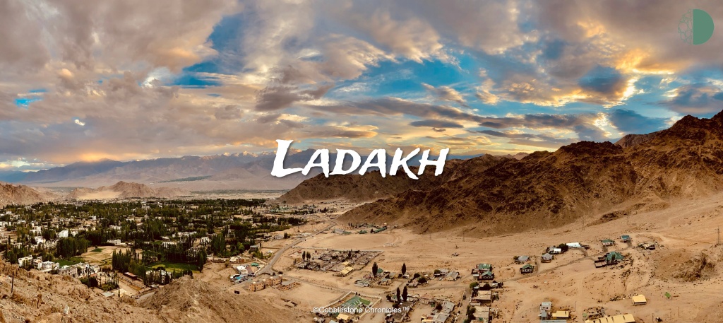
Ladakh is a place where mountains caress the sky. Along with its lofty, rocky terrain with sublime stretches of valleys and gorges, Ladakh is also known for its unique, yet beloved coalescence of chronicles and culture. It offers way more – culturally, historically and physiologically – than what it reveals at face value. In our last article, we travelled to the magnificent Tso Moriri lake and Hanle village. In this article, we shall explore the exquisite Nubra valley – its settlements, singularities and sceneries.

Ladakh oschestrates a stunning amalgamation of history, culture and landscapes. While travelling from Leh towards Nubra valley, we first made our way through one of the highest motorable roads – the Khardungla Pass. After descending towards the Shyok river near Khalsar, we explored the scintillating Diskit Gompa. We then proceeded to Turtuk and Tyakshi, India’s northernmost villages, just kilometres short of the Line of Control (LoC). We spent a night in Turtuk and started our return journey the next day towards Hunder to explore the nearby sand dunes.

Khardungla pass
Having based out of Leh for our 3-week expedition across Ladakh, the plan was to start towards Nubra valley early in the day. Being on a ‘workation’, this meant wrapping up work early the previous day, going to bed early and starting from Leh by 6am. Of course, we started by 8 o’clock. While this didn’t derail our plans for the day, it is recommended to start early when making your way through the high altitude passes. As traffic increases and the Sun becomes unbearble at high altitudes, it is often a good choice to be the proverbial early bird.

The plan was to spend some time at Khardungla pass, maybe have some breakfast there, if time permits. Later, we planned to descend to Diskit by lunch time. If everything went right (which it did thankfully), we would be in Tyakshi, just a kilometre from the Line of Control (LoC) for the sunset.
This was my second visit to this remarkable high altitude pass and I reckoned it wouldn’t have changed much since. This time, however, I got to see a completely different face of the mighty Khardungla pass. When we started from Leh, the temperature was a comfy 15°C and sparse grey clouds were looming in the distance. By the time we started to ascend the colossal mountains, the weather became gloomy, chilly and quite surreal. Only in the mountains does the weather change with every passing minute!

Unsurprisingly, as we climbed our way up, it started drizzling. As we further made our way higher into the clouds, the raindrops gradually took the form of tiny snowflakes. And as we traversed further, the clouds, the snowfall and the mountains paved the way for a heavenly experience! Like I said, this wasn’t my first visit to Khardungla pass (you can read more about it here), but it was way different than before. Mountains have often surpised me that way, they never present themselves in the same manner twice.
Atop, we had some tea and maggi (the most cliche thing to do, I know) and spent about half an hour relishing the beautiful snowfall on the top of the world! When we started descending, it was still snowing and the weather was freezing; nonetheless, we had a warm innervation having seen one of the most spectacular high mountain passes in its most natural self!

It takes about 45 minutes from Khardungla pass to descend into Nubra valley via the quaint village of Khalsar. This is also when we took our first glimpse at the gushing Shyok river, of which the Nubra river is a tributary. For as long as we travelled in the Nubra valley for the next couple days, this river always kept us company. Next stop, and our halt for the midday meal, Diskit!
Diskit
The first thing that I noticed as we descended into Nubra valley is that it is surprisingly more green than the rest of Ladakh. The fact that the land here is suitable for growing vegetation (being in the vicinity of the Shyok river bed) means that villagers make their living by cultivating a variety of crops and fruits.

From Khalsar, Diskit is around 20km. The roads are well maintained single lane pavements till the village of Skuru, thanks to the monumental efforts taken by Border Roads Organisation (BRO). As a result, we reached Diskit in less than half an hour from Khalsar.
An archaric village settlement on the banks of Shyok river, Diskit is known for its 14th century monastery, popularly known as ‘Diskit Gompa’. This gompa is located on a hillock, just above the flood plains of the Shyok, and is the largest monastery in this valley. The residence of the Chief Lama of Nubra is also located here.
Diskit Gompa

Apart from the surreal views of the Nubra valley, tourists flock at Diskit monastery to see the huge statue of the Maitreya Buddha. This gargantuan 32-metre statue is located on top of a hill besides the monastery, facing westwards down the Shyok river. It is stunning to witness this flashy statue, with the backdrop of the scintillating Himalayas! Honestly, we had seen many monasteries over the last weeks in Leh and its suburbs. The Diskit Monastery, however, was the best of the lot!
Just like all other monasteries, this one too is a hodgepodge of houses, temples, libraries, praying sanctums, shrines, and meditation halls. The gompa houses about a hundred monks and runs a school for Tibetian children in its precincts. I was surprised to learn that this school also teaches scientific subjects with sustenence from the ‘Tibet Support Group’, an NGO which strives for prosperity of the Tibetian youth in the region. This group has trained the monks and students in computer technology and English language. In the libraries here, I was pleasantly taken aback to find modern-day encyclopaedias, dictionaries and plenty other teaching materials.

The prayer halls here have a transquil ambiance and are typically dimly lit with incense sticks burning in the corners. The walls in the sanctums are colourfully painted, and outside, there is a giant drum that is said to safeguard the gompa from evil.

The Lachung Temple, which sits above the monastery, is one of the valley’s oldest temples. The pilgrims and monks worship a big idol of Tsong Khapa, founder of the Gelugpa sect, and whose pupil was a creator of this monastery.

In Diskit monastery, the decripit walls tell stories of generations – some of them mythical, others not so much. All in all, not only is this monastery a great spot to take in some mesmerising views of the Nubra valley, but its calming charisma and rich history are equally winsome. You would need around an hour and a half to see this place completely; and yes, as you guessed, this is not something you should skip!


After having a much needed luncheon in Diskit, we started towards Turtuk by around 3pm. One can easily find a few options to eat in Diskit without trouble at this time of the day. The distance between Turtuk and Diskit is close to 100km and it typically takes around two and half hours to reach there. The road dwindles alongside the Shyok till the very end, providing some fantastic views of the river!

Exploring villages on the edge of India
Around 5:30pm, we reached Tyakshi. Turtuk, Tyakshi and Thang are the ternary Indian settlements along the Shyok river before it enters the Gilgit-Baltistan territory (which is the part of Pakistan Occupied Kashmir). The road from Skuru (about 50km from Diskit) to Tyakshi is not in the best condition, but considering the rugged weather and connectivity here, we couldn’t complain! As we were approaching Turtuk, the significance of this place gradually seeps in – historically, these villages only became a part of India after the Indian Army took control of the region in the 1971 Indo-Pakistan war.

History of Tyakshi and Turtuk
For 24 years after independence, the villages were under the governance of Pakistan and one can still see the remnants of that era, and the conflicts there about. A few kilometres before Tyakshi, we started seeing the age-old stone bunkers erected by the Indian Army during the war. An aggregation of countless bunkers, just a few hundred feet from the road on both sides along the mountains continue all the way to Turtuk and beyond till the LoC. Even though most of them are unused now, to abide by the security morals of the Army, it is recommended not to click photos of them. The presence of bunkers is a stern reminder that this place wasn’t always as easily accessible as it now is.

Tourism started in Turtuk and Tyakshi only after 2010, and the Army opened Thang to visitors partially after 2018. As a result, there aren’t many tourism facilities. Our plan was to visit Tyakshi and Thang and then come back to Turtuk (being the biggest settlement of the three) to find a place to stay for the night. As we reached Tyakshi, some 2.5km ahead of Turtuk, we were made aware at the Army checkpost that the road to Thang was closed because of security reasons and this is as far as we could go. This isn’t uncommon along the border area and one can visit Thang only on selected days, if you are lucky enough!

Tyakshi village
The road to Tyakshi to goes only as far as the parking area, and one has to explore the village on foot. The moment we entered the village, a couple of kids took us by our hands, and quite literally gave us a guided tour of the burg! There is a small concrete pathway which runs through the village, surrounded by bamboos, apricot and apple trees. Tyakshi is well-known for some quite interesting quirks. The people here follow Islam as their religion, which is intriguing as a majority of Ladakhis are Buddhists. However, the ancestors of these villagers came from Pakistan and they still have their families located across the border towns.
The kids proudly showed us the Indian flag waving atop the colossal mountain in the front (they will eagerly give you binoculors to see this), with Pakistani bunkers located on the adjacent mountain. It is always surreal to see borders, and this was the LoC, no less! Moreover, this is the region where Himalayas exchange hands with the mighty Karakoram mountains, though you can’t literally draw a line between the two ranges.


Standing on the edge of your beloved country, that too, at a place which was hard earned by many a brave soldier is an emotional experience. The villagers here told us stories of how the area was also threatened during the Kargil War of 1999. They told us how some of their relatives still live across the border, just a couple kilometres away as the crow flies. However, to meet them, they have to go to Amritsar, cross into Pakistan through the Wagah border and then travel all the way up to Gilgit-Baltistan on the other side to visit them. The Indo-Pak peace and diplomatic corridor helps them in doing so. Despite the hardships brought about by staying in such a vulnerable and sensitive area, these villagers are ardent citizens and support the Indian Army in every way they can.
Another interesting attraction of this village is the now dilapidated school which was constructed by the Government of Pakistan prior to 1971. After the war, the school was taken over and administered by Indian authorities.

In this village, growing apricots and apples is the prime chore. In fact, Nubra valley produces some of the best apricots in India! We savoured few freshly picked apricots before having some snacks right on the edge of the village. The Sun was setting by this time, and we were mesmerised by the disposition of being at such a remarkable place – a village of stunning beauty, with placid lifestyle and situated right on the LoC!
Turtuk village
To stay for the night, there a few options in Tyakshi as well; however, as we had to explore Turtuk the next day, we chose accordingly. By the time we started back to Turtuk, it was late and darkness had almost completely set in. Thankfully, not long after we arrived in Turtuk, we found a good place to stay at an economical price. Lodges and guestrooms are available here for as less as ₹700 a night, and villagers will point you to the nearest available lodge; just ask any bystander! Surprisingly, despite the aloofness, we found some quite good cafes and restaurants here. Soon enough, we had a wholesome dinner in a cafe by the name of ‘Friends cafe’, which was quite good (and expensive too; but then in an area as remote as this, you take what you get!). Being full and tired after a long day, we went straight to bed, excited to see what Turtuk and Hunder had in store the following day!

The coming morning, as we got out of the lodge to explore Turtuk, I was stunned by the picturesque beauty of the place. Turtuk is a textbook example of a quiet little village amidst the tall mountains. Apricot trees and other high-altitude crops are planted at every corner and narrow stone pavements run through the village across its length. Turtuk is also blessed by fertile lands and relatively good weather; as a result, the villagers survive on fruit plantations mostly.

The rustic and bucolic houses, the fresh aroma of apricots and morning dew, all give way to a snug conconction that is only attainable in faraway mountain boroughs! Turtuk does not have any room for unique particular activities. Just roaming around in the village on foot, roving across the fields and orchards by itself is an experience I will remember forever. After spending some time and having our breakfast, we started towards Hunder.
Hunder
Hunder is a remote, yet beautiful village, about 7 km from Diskit (and about 90km from Turtuk). The serene sand dunes and Bactrian camels are the reason Hunder is well known globally!

Native to central Asia, the Bactrian camels found here have two humps. Historically, these camels were the main mode of transport when Ladakh was an important stopover on the trade routes with Central Asia. While you can take a ride on the camels, I chose not to give them trouble, and went on exploring the place myself. The whole terrain of Ladakh is rocky and barren, but the desert of Hunder is unique in its own way. Even though I had read about it, until I saw them with my own eyes, I didn’t quite believe that sand dunes and camels do exist in the Himalayas! Apart from camel riding, you can also Go-Kart here, one of best destinations to do so, in my knowledge!

After exploring so much of Ladakh, it still managed to surprise me somehow – stunning mountains, picturesque valleys, rivers that artistically cut through the colossal gorges and now, cold deserts! After spending an hour here (mostly, clicking pictures), we went ahead to have our lunch and find us a place to spend the day in Hunder. This is a small town with limited facilities; so, finding a good place to stay will need some efforts!
As my expedition across this stunning valley came to an end, all I could do was look back and relish over and over in my mind the spectacular places I had been to! Right from the largest monastery in the region promoting tranquility to the highly secured Line of Control, from one of the highest motorable roads to the cold deserts, Nubra valley stands out as the most vivid and diverse valley in Ladakh!

The day after, even though we left to Leh, Nubra valley stayed in my heart. Even today, I still relive those moments every now and then!

Leave a comment